
Research
I develop my research program around a fundamental question: How can we better understand and foster resilient human–environment systems in a rapidly changing world? My research brings together satellite remote sensing, field measurements, causal inference, and geospatial AI to uncover how ecosystems and societies respond to disturbance, adapt to long-term change, and influence one another from local to global scales. My ultimate goal is to advance a predictive and actionable science of resilience that identifies emerging vulnerabilities, anticipates future change, and informs strategies to strengthen both natural and human systems.
1. Vegetation Resilience and Ecosystem Dynamics
How do forests and ecosystems respond to disturbance, recover from stress, and gain or lose resilience under global environmental change?
Lag-1 temporal autocorrelation (TAC) is one of the most widely used indicators of ecosystem resilience because increasing TAC can signal a system’s declining recovery rate from stress. However, its ecological meaning has rarely been tested directly in real ecosystems, limiting confidence in its use for large-scale resilience monitoring.
In our study, we combine satellite time series with field-based physiological measurements to connect patterns observed from space with the mechanisms that govern vegetation resistance to drought. In the Amazon, we demonstrated that a Landsat-derived TAC captures meaningful variation in community-level hydraulic safety margin. We also provide methodological guidance for robust satellite-based TAC estimation, identifying appropriate temporal frequencies, rolling-window lengths, and vegetation state variables.
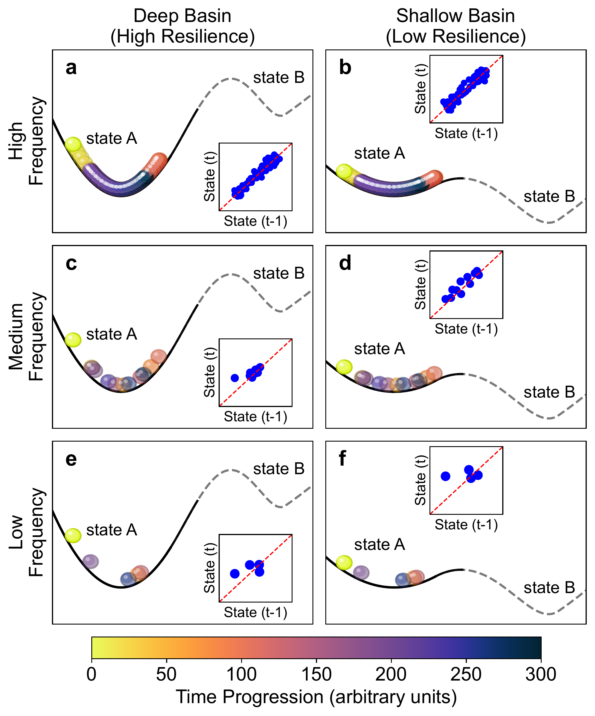
Fig. 1. A conceptual basin stability diagram illustrating how observational frequency influences estimates of ecosystem resilience.
My work also evaluates forest disturbance dynamics using dense satellite time series, with a particular focus on detecting disturbance timing, severity, and recovery under diverse natural and anthropogenic stressors.
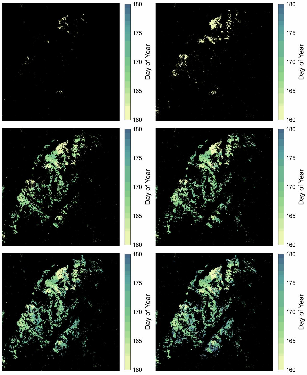
Disturbance Timing
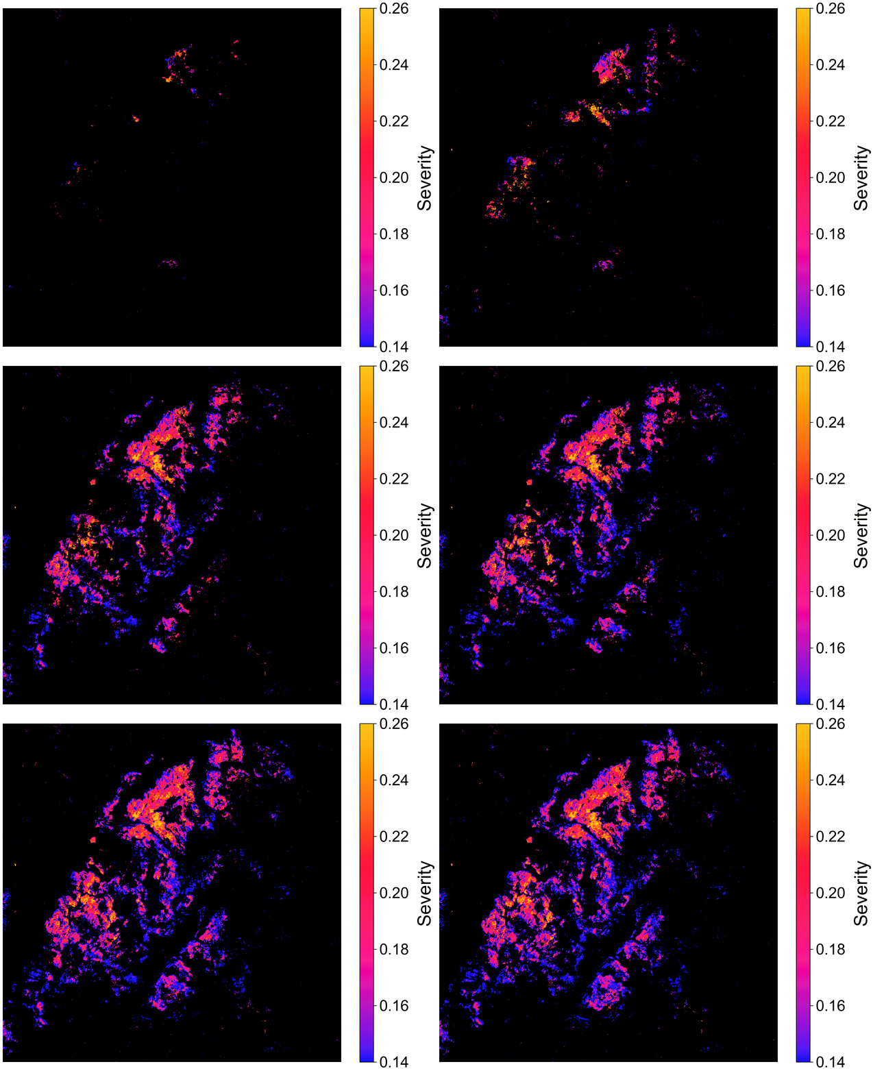
Disturbance Severity
Fig. 2. Spongy moth outbreak detected from 10-m Harmonized Landsat and Sentinel-2 imagery (Song et al., 2025). Left: disturbance timing inferred from the detected disturbance onset. Right: disturbance severity represented by the detected disturbance magnitude.
Related Publications
-
Song, K., Knighton, J., Qiu, S., Yang, X., Suh, J. W., Tavares, J. V., Liu, Y., Tai, X., Fahey, R., Neigh, C. S. R., Callahan, R., Hong, F., Li, T., Grinstead, A., Ren, W., Witharana, C., Hedges, S. B., Yang, Z., Leite, R. V., Bittencourt, P. R. L., & Zhu, Z. (2026). Physiological fidelity of a satellite-derived forest resilience indicator in the Amazon. Nature Ecology & Evolution. Paper
-
Qiu, S., Zhu, Z., Yang, X., Woodcock, C. E., Fahey, R. T., Stehman, S. V., Zhang, Y., et al. (2025). A shift from human-directed to undirected wild land disturbances in the USA. Nature Geoscience, 18, 989–996.
Selected Conference Presentations
- Song, K. & Zhu, Z. (2024). Can We Reliably Measure Forest Resilience from Space? AGU Fall Meeting, B23K-01.
- Song, K. & Zhu, Z. (2024). Unveiling Forest Resilience Changes in Response to Insect Disturbance: A Comprehensive Analysis Using PlanetScope Time Series. Annual Meeting of the American Association of Geographers (AAG).
- Zhu, Z., Suh, J. W., Hong, F., Song, K., Qiu, S., Yang, Z., & Hedges, S. B. (2025). Mapping Caribbean Primary Forest Change Considering Disturbance History, Resilience, and 3D Structure. AGU Fall Meeting.
2. Environmental Governance, Urbanization, and Socio-Ecological Systems
How do human behavior, governance, and infrastructure interact with environmental change to reshape landscapes and influence the resilience of coupled human–natural systems?
We investigate how conflict, human displacement, infrastructure expansion, and environmental interventions reshape coupled human–natural systems. Current projects combine dense satellite time series with causal inference and geospatial AI to evaluate land-system changes associated with conflict and refugee displacement, emerging infrastructure such as data centers, and environmental management interventions.
Our previous research examines human–environment interactions across cities, infrastructure, and managed landscapes. We use satellite observations and interdisciplinary approaches to reveal the spiky, cyclical, and asynchronous nature of urbanization and track the increasing volatility of nighttime human activity.
Together, these studies show how human systems and environmental processes co-evolve across space and time, and how improved observation can reveal complex trajectories of human activity and landscape change.
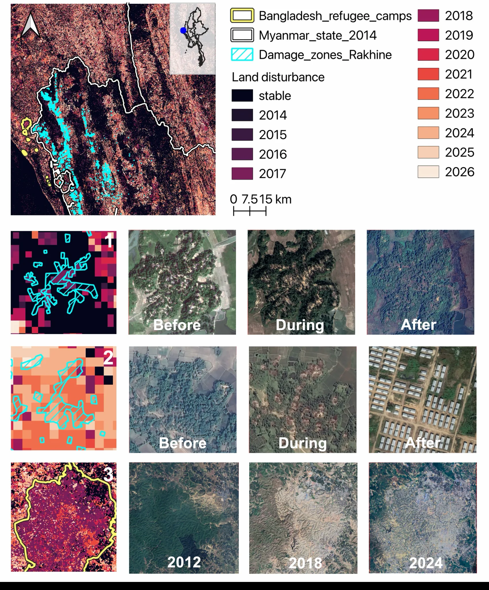
Fig. 3. Satellite-derived land disturbance trajectories across northern Rakhine State, Myanmar, and refugee settlements in Bangladesh. Examples illustrate landscape changes before, during, and after major conflict and displacement events.
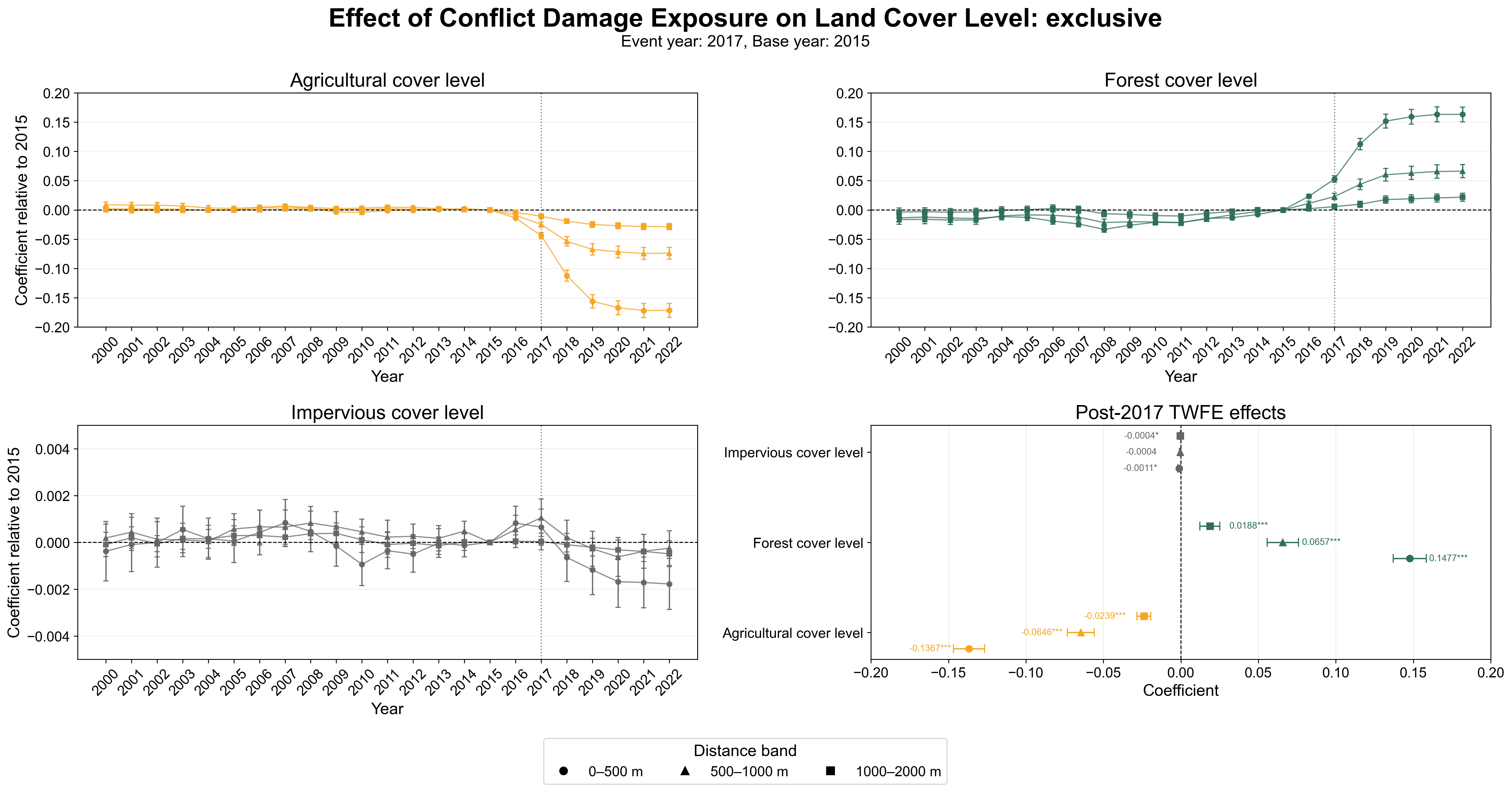
Fig. 4. Estimated effects of conflict-damage exposure on agricultural, forest, and impervious land-cover trajectories using a two-way fixed-effects framework.
Related Publications
-
Zhu, Z., Fragkias, M., Suh, J. W., McCoshan, E., Chen, L., Song, K., Kong, J., Li, T., et al. (2026). The Urban Pulse: Diagnosing the urbanization process as spiky, cyclical, and asynchronous. Proceedings of the National Academy of Sciences, 123(24), e2537770123. Paper
-
Li, T., Wang, Z., Kyba, C. C. M., Román, M. O., Seto, K. C., Yang, Y., Qiu, S., Kuester, T., et al. (2026). Satellite imagery reveals increasing volatility in human night-time activity. Nature, 652, 379–386.
-
Sanford, L. & Song, K. (in prep). Seeing like a satellite: How to effectively use remote sensing data for social science inquiry.
3. Geospatial AI, Remote Sensing, and Methodological Innovation
How to connect big data, artificial intelligence, and high-performance computing to solve contemporary Earth and environmental challenges?
A central thread of my research developing methodological frameworks to monitor, model, and anticipate land-system change from local to planetary scale. My work spans multi-sensor satellite data fusion, change detection, explainable machine learning, geospatial active learning, and physics-informed neural networks.
Multi-sensor Satellite Data Fusion for Advanced Land Monitoring
I developed the Time-series-based Image Fusion (TIF) algorithm to harmonize Landsat and Sentinel-2 imagery into a dense 10-m optical time series. This work has been published in Remote Sensing of Environment and is being integrated into NASA’s Harmonized Landsat and Sentinel-2 (HLS) pipeline. This work enables high-resolution monitoring of land changes, such as insect disturbance detection, crop phenology monitoring, and flash flood mapping.
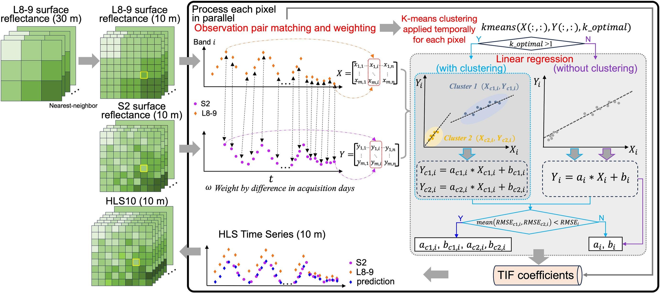
Fig. 5. Workflow of the Time-series-based Image Fusion (TIF) algorithm.
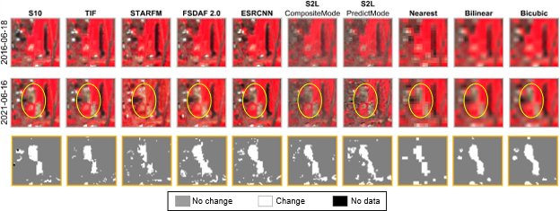
Fig. 6. Comparison of change maps generated from Sentinel-2 (S10, reference), TIF (our approach), and other image fusion and resampling methods. Gray indicates stable surfaces, white indicates detected changes, and black represents invalid pixels masked by the QA band. The yellow circle highlights a land-cover conversion from forest to bare land.
Related Publications
-
Song, K., Zhu, Z., Qiu, S., Olofsson, P., Neigh, C. S. R., Ju, J., & Zhou, Q. (2025). TIF: A time-series-based image fusion algorithm. Remote Sensing of Environment, 331, 115035. Paper
-
Song, K. & Minnett, P. J. (2024). Evaluation of summertime passive microwave and reanalysis sea-ice concentration in the central Arctic. Earth and Space Science, 11(1), e2023EA003214.
Selected Conference Presentations
- Song, K. & Zhu, Z. (2022). Improved Subtle Change Detection Using Landsat and Sentinel-2 Data Fusion: A Study of Spongy Moth Outbreaks in New England Forests. AGU Fall Meeting, B43B-08.
- Song, K. & Zhu, Z. (2021). Forest Disturbance Monitoring at 10 m Spatial Resolution Using Sentinel-2 Time Series. AGU Fall Meeting, B45I-1732.
4. Stakeholder-Engaged Research
I work closely with stakeholders to translate Earth observation and geospatial data science into actionable decision-making support, connecting scientific advances with real-world societal challenges.
Vegetation Risk and Infrastructure Vulnerability Assessment
In collaboration with the StormWise program and the Eversource Energy Center, I developed machine learning models that integrate satellite, aerial, LiDAR, and infrastructure data to quantify vegetation-related power outage risks. This work translates environmental monitoring into actionable insights for utility vegetation management and community-level storm damage mitigation.
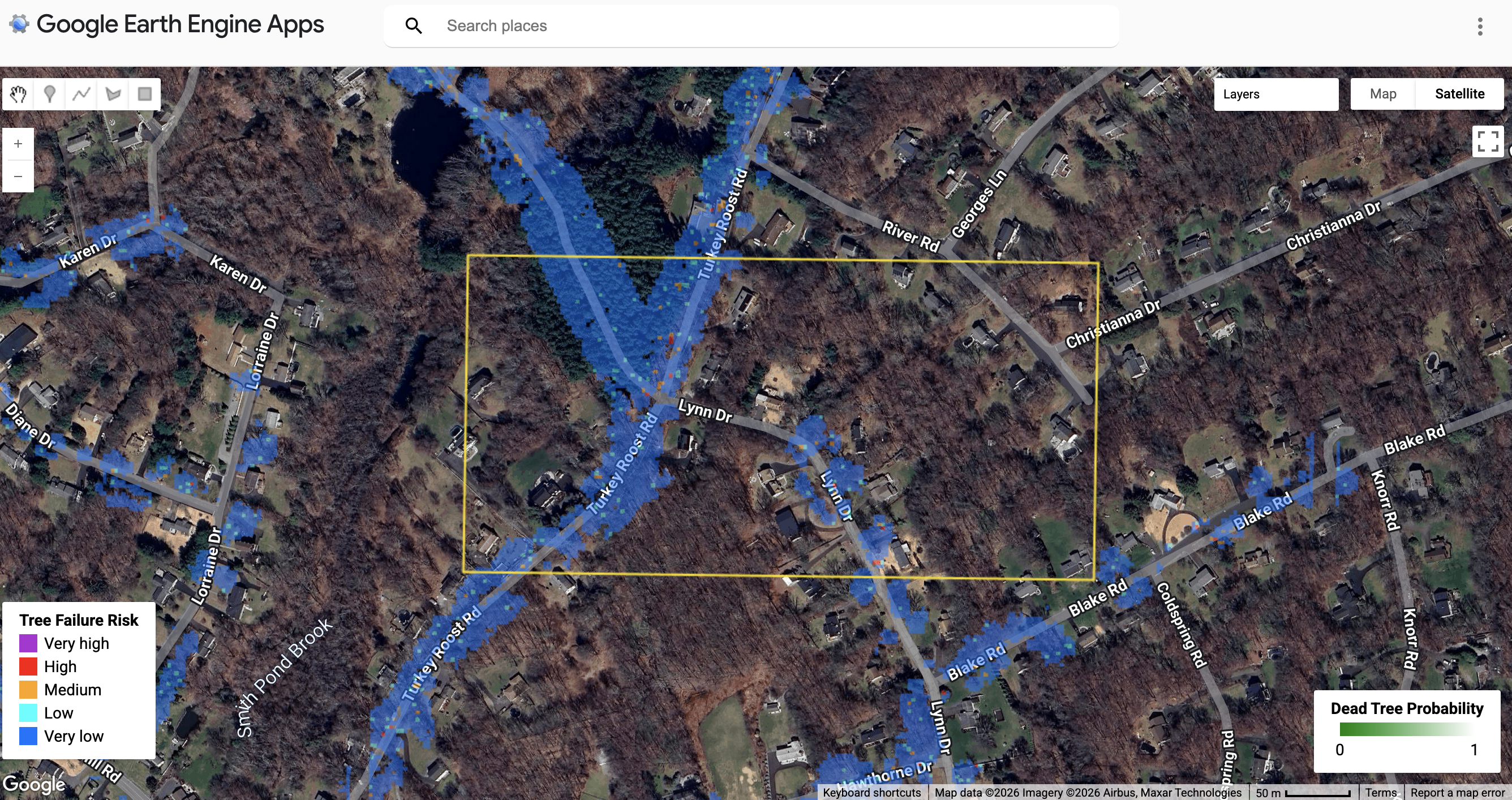
Fig. 7. Predicted roadside tree failure risk map. Click the figure to explore the interactive Google Earth Engine application.
Related Publications
- Worthley, T., Bunce, A., Morzillo, A. T., Witharana, C., Zhu, Z., Cabral, J., Crocker, E., et al. (2024). Stormwise: Innovative Forest Management to Promote Storm Resistance in Roadside Forests. Journal of Forestry, 122(4), 398–409.